-
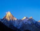
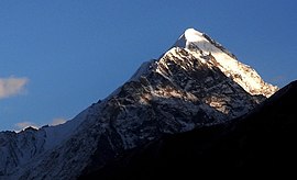
FEATUREDFeaturedGasherbrum IV (Urdu: ???? ??? -4?;), surveyed as K3, is the 17th highest mountain on Earth and the 6th highest in Pakistan. It is one of the peaks in the Gasherbrum massif. Read more...
-
FEATUREDFeaturedSaltoro Kangri is the highest peak of the Saltoro Mountains, also known as the Saltoro Range, which is a part of the Karakoram. It is the 31st highest mountain in the world, but it is in a very remote location deep in the Karakoram. It is located on the Actual Ground Position Line between Indian controlled territory in the Siachen Read more...
-
FEATUREDFeaturedChongra Peak (Urdu: چونگرا چوٹی) is a peak in the Himalaya range of Asia. Located in Gilgit–Baltistan, Pakistan, it is one of the many subsidiary summits of the Nanga Parbat massif. The peak lies just south of the Indus River, in Pakistan. Not far to the north is the western end of the Karakoram range. Read more...
-
FEATUREDFeaturedMiar Peak (Urdu: میار چوٹی) is a mountain in Hispar Valley in the Nagar Valley of Gilgit-Baltistan, Pakistan. It lies southeast of Diran peak (7,257 m) and northwest of Malubiting peak (7,428 m). Read more...
-
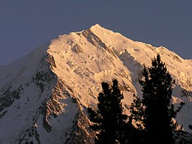
FEATUREDFeaturedGanalo Peak (Urdu: گینالو) is a subsidiary peak of Nanga Parbat in Pakistan’s western Himalayas. Anchoring the rock and ice battlements northwest of Nanga Parbat’s main summit, Ganalo rises 9,000 feet above the Rakhiot Glacier and 8,000 feet above the nearby Rakhiot Base Camp. The remote village of Beyal rests at its northern base. Ganalo Peak is easily viewed from Fairy Meadows, a popular trekking destination high above the Indus River Read more...
-
FEATUREDFeaturedThe Gul Lasht Zom is a 6657 m high mountain in the Hindu Kush in the Pakistani province Khyber Pakhtunkhwa . The Gul Lasht Zom can be seen as a pyramid of snow from the Upper Tirich Glacier . The mountain rises west of the Upper Tirich Glacier 14.5 km northwest of the Tirich Mir and 12.3 km southwest of the Noshak . To the west, it is drained by the Arkari Gol , a left tributary of the Lutkho . 1.9 km east Read more...
-
FEATUREDFeaturedThe Thui II is one of the highest mountains of the Hindu Raj -Gebirges. Thui II is located on a northern spur off the main ridge of northern Hinduraj. It is located on the district boundary of Chitral and Ghizer . The 6523 m high mountain is flanked to the west by the Risht Glacier and to the east by the Ponarillo Glacier . Both glaciers flow north to Yarkhun . The Thui I is located 10 km to the east.a Read more...
-
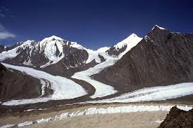
FEATUREDFeaturedThe Koser Gunge is a mountain in the Masherbrum Mountains , a chain of Karakorum . The Koser Gunge is located east of the Shigar River Valley in the far west of the Masherbrum Mountains . The mountain is eponymous for the surrounding mountain group, the so-called Koser-Gunge group . The first ascent took place in 1899 by the American Fanny Bullock Workman . The height is given in the literature as 6401 m . According to the topographic map Read more...
-
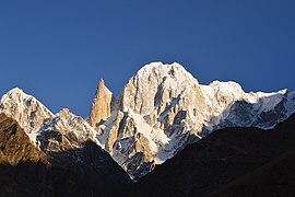
FEATUREDFeaturedThe Bublimotin, Bubli Motin, Bublimating or Ladyfinger Peak (Urdu: لیڈی فنگر), is a distinctive rock spire in the Batura Muztagh, the westernmost subrange of the Karakoram range in Pakistan. It lies on the southwest ridge of the Ultar Sar massif, the most southeasterly of the major groups of the Batura Muztagh. The whole massif rises precipitously above the Hunza Valley to the southeast. Bublimotin, while having little prominence above the saddle with nearby Hunza Peak, is particularly notable Read more...
-
FEATUREDFeaturedThe Chari Khand ( Charikand otherwise spelling ) is a 5886 m (according to other sources 5888 m ) high mountain in the extreme west of the Karakorum Mountains in the Pakistani Special Territory Gilgit-Baltistan . Read more...
-
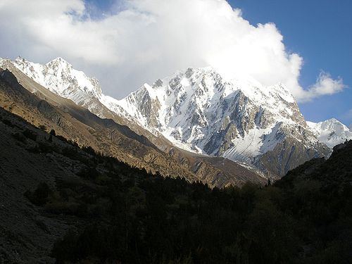
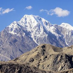
FEATUREDFeaturedShaigiri (Urdu: شایگیری)is a mountain in Pakistan’s western Himalayas. The peak rises precipitously from the south end of the Rupal Valley, soaring 5,584 metres (18,320 ft) above sea level and some 6,500 ft (1,980 m) above the valley floor. To its east stands Rupal Peak, to its west, the iceflows of Rupal Glacier. Despite its impressive height and unique pyramid shape, Shaigiri is greatly overshadowed by its giant neighbor to the north, Read more...
-
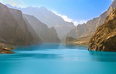
FEATUREDFeaturedAttabad (Urdu: عطا آباد), also spelt Atabad, is a town in the Gilgit-Baltistan region of northern Pakistan. It is located at 36°19’0N 74°48’0E with an altitude of 2559 metres (8398 feet), and is famous as home of the Attabad Lake. Read more...
.