places Categories: Attractions and City Sightseeing
Phong Nha Cave is a cave in Phong Nha-Kẻ Bàng National Park, a UNESCO World Heritage Site in Quảng Bình Province, Vietnam. It is 7,729 metres long and contains 14 grottoes, as well as a 13,969 metre underground river. While scientists have surveyed 44.5 kilometres of passages, tourists are only allowed to explore the first 1500 metres.
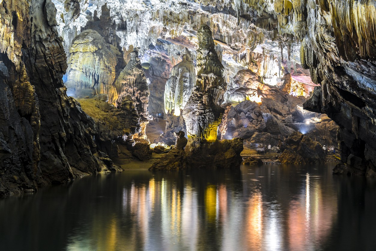
Phong Nha cave, from which the name to the whole system and the park is derived, is famous for its rock formations which have been given names such as the “Lion”, the “Fairy Caves”, the “Royal Court”, and the “Buddha”. Phong Nha cave is 7729 m long but tourists can only penetrate to a distance of 1500 m.and contains several grottoes or chamber, including the Bi Ky grottoes.
Its cave system features underground passageways and river caves filled with stalactites and stalagmites. The stalagmites that used to stand at the cave’s entrance apparently inspired its name: Phong Nha means ‘Wind and Teeth’.
Phong Nha is famous for its rock formation that bear intriguing names such as the ‘Lion’, ‘Unicorn’, ‘Kneeling elephant’ and ‘the Buddha’. After flowing about 19 km underground, the Son river emerges from the mouth of this cave, draining a huge area of the limestone mountains around Phong Nha.
Phong Nha has been voted as one of the most wonderful caves in the world for a number of reasons: for its longest underground river, for its most beautiful underground lake. for its highest and widest entrance, for its most beautiful and widest dry cave, for its most beautiful sandbank and reef, as well as for its most spectacular stalactites, stalagmites and longest water grottos.
No Records Found
Sorry, no records were found. Please adjust your search criteria and try again.
Google Map Not Loaded
Sorry, unable to load Google Maps API.
-
- Sơn Trạch, Bố Trạch District, Quang Binh Province, Vietnam
Quang Binh
Quang Binh
Vietnam -
The Imperial City (Vietnamese: Hoàng thành) is a walled enclosure within the citadel (Kinh thành) of the city of Huế, the former imperial capital of Vietnam. The grounds of the Imperial City are protected by fortified ramparts 2 kilometers by 2 kilometers, and ringed by a moat. The water in the moat is routed from the Perfume River through a series of sluice gates. This enclosure is the citadel (Kinh Read more...
-
The Cham Islands (Vietnamese: Cù lao Chàm) constitute a group of 8 small islands of Quảng Nam, which form a part of the Cu Lao Cham Marine Park, a world Biosphere Reserve recognized by UNESCO, in the South East Asia Sea in Vietnam. The islands are approachable from Cửa Đại beach. The islands are also recognized as Vietnam’s national scenic site. The islands grouped under the Cham Islands are: the Hòn Read more...
-
Ha Long Bay is a UNESCO World Heritage Site and popular travel destination in Quang Ninh Province, Vietnam. The name Hạ Long means “descending dragon”. Administratively, the bay belongs to Ha Long City, Cam Pha City, and is a part of Van Don District. The bay features thousands of limestone karsts and isles in various shapes and sizes. Ha Long Bay is a center of a larger zone which includes Bai Tu Long Bay to Read more...
-
Koh Ker is a remote archaeological site in northern Cambodia about 120 kilometres (75 mi) away from Siem Reap and the ancient site of Angkor. It is a very jungle filled region that is sparsely populated. More than 180 sanctuaries were found in a protected area of 81 square kilometres (31 sq mi). Only about two dozen monuments can be visited by tourists because most Read more...
-
Angkor Thom (“Great City”), (alternate name: Nokor Thom, Khmer) located in present-day Cambodia, was the last and most enduring capital city of the Khmer empire. It was established in the late twelfth century by King Jayavarman VII. It covers an area of 9 km², within which are located several monuments from earlier eras as well as those established by Jayavarman and his successors. At the centre of the city Read more...
-